This image shows an area of the Moon that includes the Apollo 15 landing site. On July 30, 1971, Scott and Irwin landed the Falcon LEM on the surface of the Moon near Mons Hadley Delta. This was the first Apollo mission that included a lunar rover vehicle. The astronauts visited Rima Hadley and collected 76.8 kg of rocks. Mouse over this image and an annotated version of the image appears that has features shown in the image labeled, including the Apollo 15 landing site.
Montes Alpes is a mountain range alongside Mare Imbrium. The highest peak in the range is Mons Blanc at a height of 10,900 feet. Vallis Alpes (Alpine Valley) is a deep valley that cuts the Montes Alpes mountain range in two. This immense fault has raised cliffs on each side, and the 7 mile wide valley extends for a length of 79 miles. Vallis Alpes is a striking spectacle when viewed through a telescope. There are at least three theories concerning how this valley might have formed from a once molten Moon subjected to a period of heavy bombardment. One theory is that this great valley formed by slumping of the crust along stress fractures when the lunar mantle expanded slightly in a horizontal direction after the regolith had first solidified. Alternatively, the crust may have shrunk slightly after its initial solidification and stress fractures developed as a result. A third hypothesis is that the colossal impact event that formed the Imbrium basis was responsible for the fault that ultimately produced this valley. Proponents of this theory point to evidence of other linear features that extend radially from Mare Imrium. Close examination of Vallis Alpes shows that the floor of the valley was once flooded with lava. Under excellent seeing conditions, a telescope with good optical quality may reveal a sinuous rille that meanders along the length of the floor of this lunar valley. It is interesting to contemplate how this striking massive scar on the lunar landscape may have been formed.
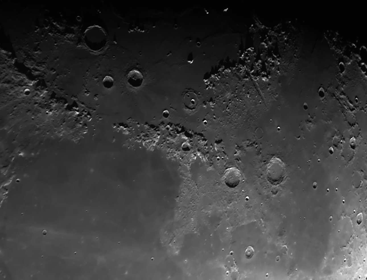
Mare Imbrium (Sea of Showers) is a multi-ring basin. The outer ring consists of mountain ranges formed from uplifted crust, undoubtably the result of the massive impact that created Mare Imbrium. In addition to the Montes Alpes mountain range, this outer ring includes the Montes Caucasus mountain range and the Montes Apennius mountain range. This images shows other mountain ranges in this area of the Moon, such as the Montes Archimedes mountain range and the Montes Spitzbergen chain of mountains. All that survives of the innermost ring of Imbrium basin are a few isolated mountains that poke through the relatively smooth surface of Mare Imbrium. For example, to the left of the Montes Alpes mountain range in this image, the isolated mountain Mons Piton towers 6,800 feet above the lava flood plain.
Archimedes crater is immediately to the right of the Montes Archimedes mountain range. Archimedes is the largest crater on Mare Imbrium, and often attracts attention as a focal point of the mare even though it is off center. It is 50 miles (83 km) in diameter and has a very flat floor. The steep slopes of the crater walls extend 6,500 feet above the crater floor and have terraces. The rim of Archimedes rises almost 1.9 km above the surface of Mare Imbrium in places. Notice the shadow cast on the floor of Archimedes by the rim of the crater at the low sun angle in this image. The spire-like shadows magnify the jagged profile of the rim itself. The floor of Archimedes was filled with lava after the crater formed. With a very good telescope under excellent seeing conditions, you can sometimes make out tiny craters within Archimedes. The two major craters nearest to Archimedes in this image are Autolycus and Aristillus. Autolycus is 39 km in diameter and 3.4 km deep. Aristillus is 55 km in diameter and slightly deeper. Aristillus has raised outer slopes and a ray system. The ejecta pattern splashed across the mare around Aristillus, and the triple mountain peaks rising almost 1 km above the floor of Aristillus, combine to make this a fascinating crater to observe with a telescope.
Cassini crater is situated at the southern extremity of the Montes Alpes and the northernmost section of the Montes Caucasus mountain range. This crater may have formed relatively soon after the period of major flooding that filled the Imbrium basin about 3.3 billion years ago, because the 57 km diameter crater has complex and broad outer ramparts and an ancient floor partially filled with mare-type lavas. If the crater-forming impact occurred while the cooling lava that filled the mare still had a thin crust, a subsequent upwelling of lava could have resulted from fissuring of the still thin crust under the crater. The floor of Cassini is old, because it is covered with small craters. The two largest craters in the floor of Cassini are very conspicuous and together give Cassini its unmistakably distinctive appearance. The largest of the two is known as Cassini A, and is 15 km in diameter. The smaller one is called Cassini B and has a diameter of 9 km.
Aristoteles crater is the largest crater in this image with a diameter measuring 53 miles (87 km). It is just south of the "shore" of Mare Frigoris. Aristoteles has two small mountains off-center in the crater. This crater also has very finely terraced walls that extend more than 3.3 km above the floor of the crater. Eudoxus is a prominent crater to the south of Aristoteles. These two craters are not exactly circular, but instead display polygonal outlines. An interesting arc of mountain peaks spans the gap between these two craters to the north. Modern day observers of the Moon are left to ponder on the events and processes that led to the many interesting formations we see today on the Moon.
In sharp contrast to the rugged terrain of the mountain ranges in this image, the 394 mile wide surface of Mare Serenitatis (Sea of Serenity) is so smooth, it was mistaken in Galileo's time (before the invention of the telescope) as a large sea on the Moon. This mare was formed by lava floods on the surface of the Moon more than 3.8 billion years ago. In 1651, an Italian Jesuit named Giovanni Riccioli published a map that, in addition to naming many "seas" on the Moon, also gave names to many "lakes" such as Lacus Mortis (Lake of Death) and Lacus Somniorum (Lake of Dreams). Apollo 17 landed near the southeastern border of Mare Serenitatis. In 1973, the Russians landed an unmanned robotic lunar roving vehicle called Lunokhod 2 (Luna 21) in Mare Serenitatis.
This CCD image of the Moon was taken with a Takahashi FCT-150 refractor with a 4x PowerMate at f28 using an SBIG ST-8XE CCD. This image of the Moon was taken when it was nine days old, and the waxing Moon was past first quarter. The side of the Moon facing us was 72% illuminated, and the Moon was 28 degrees above the horizon.
Moon
July 30, 2009
Image by Sid Leach
Scottsdale, Arizona
Recent Images.
Complete list of images.
Description of equipment used to acquire images.
Home
Feedback and comments should go to Sid